
One of the key trends emerging in the Global Navigation Satellite System (GNSS) industry is the advancement of high-precision GNSS, which is capable of delivering centimeter-level accuracy. Some of the applications where high-precision GNSS solutions are being used include automotive, commercial Unmanned Aerial Vehicles (UAVs), precision agriculture, surveying, robotics, and heavy machinery navigation. To deliver high-precision GNSS location positioning, implementers and solution providers must seriously pay attention to chipset diversification, the application of corrective services like Real-Time Kinematics (RTK), and sensor fusion.
High-Precision GNSS Starts with Multi-Frequency Chipsets
Multi-frequency (or dual-frequency) chipsets are crucial for delivering highly precise GNSS signals because they mitigate the effects of two common errors: multipath errors and ionosphere errors. Often, a satellite signal is delayed because it reflects off objects, such as a building. So, if a GNSS deployment is used for an autonomous vehicle within a dense city center, which is a common scenario, the constant delay will result in an inaccurate position calculation. Adding to multipath, the ionosphere sometimes interrupts and delays the GNSS receiver signal—reducing the accuracy by as much as 5 Meters (m) or more.
How Do Multi-Frequency Chips Help Make GNSS More Precise?
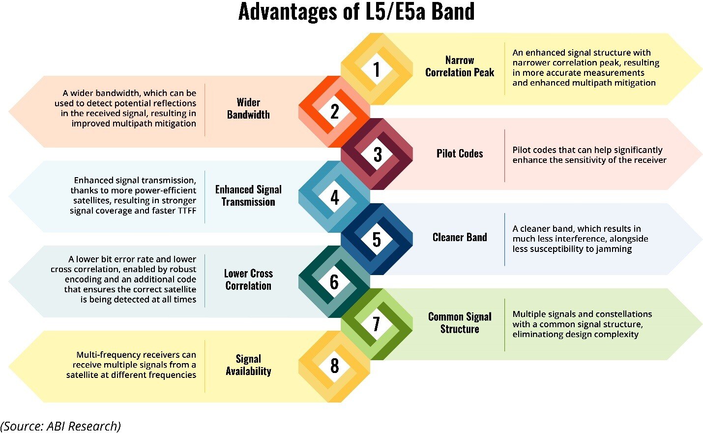
Instead of relying on a single frequency, multi-frequency GNSS receivers leverage multiple satellite signals at various frequencies, including the more superior L5/E5a band. A chipset that supports multiple bands brings a stronger signal structure and wider bandwidth to detect possible reflections in the received signal, resulting in enhanced multipath prevention.
Moreover, multi-frequency and dual-frequency GNSS mitigate the adverse effects of ionospheric interference as it can compare each delay from the two different frequencies, and then fix it. To take things further, if the L5/E5a band is used, the signal will be cleaner and more resilient to band interference. The L5 wideband signals are so much better than L1 that some vendors, such as oneNAV, are providing L5-only GNSS receivers.
Figure 1: Advantages of Using the L5/E5a Band for GNSS
High-Precision GNSS Uses Multi-Constellation Chipsets, Too
Just like supporting multi-band makes a GNSS more reliable, a wider range of constellation support improves GNSS accuracy. A multi-constellation receiver has the ability to accept signals from a number of global constellations like GPS, GLONASS, BeiDou, and Galileo, in conjunction with regional constellations, such as NavIC, and QZSS. Multi-constellation supports accurate global positioning by:
- Increasing signal availability, which decreases the signal acquisition time and Time to First Fix (TTFF)
- Strengthening signal visibility because it helps deter the influence of physical obstructions like buildings and foliage.
- Improving redundancy, as it can use signals from several constellations. In turn, failures can be prevented and spoofing is not as simple as it would be with a single constellation setup.
- Enhancing accuracy due to the higher likelihood of obtaining an ideal signal and multipath correction capabilities.
Multi-constellation has been fully embraced in the GNSS market, with 87% of the market having supported three or more constellations in 2021. By 2026, that number is expected to climb to 95%.
The Role of Real-Time Kinematics
RTK is a GNSS positioning technique that uses cellular carrier measurements to deliver tracking within 1 Kilometer (km) accuracy. In this process, a static base station, with a known location, transmits location corrections to a moving rover. As a result, the rover can provide centimeter-level precision in real time. Increasingly, many GNSS solution providers like u-blox are focused on integration between RTK and Precise Point Positioning (PPP) to deliver even greater error mitigation.
GNSS Correction Services
The list below highlights several companies that provide positioning correction services, which are integral to high-precision GNSS.
- HERE Technologies offers the cloud-based correction service High Definition Global Navigation Satellite System (HD GNSS), which leverages both PPP and RTK. For mobile use cases, accuracy is sub-meter, and for automotive, that number is as low as 20 cm. At some point in the future, HERE plans to reach widespread centimeter-level accuracy. Autonomous driving in poor weather conditions and assisted driving are key use cases for HD GNSS.
- PointPerfect, a PP-RTK corrections services solution from u-blox, targets myriad mass-market deployments. That includes UAVs, robots, machinery automation, micro-mobility, and automotive applications.
- Swift Navigation’s Skylark product collects data from hundreds of GNSS reference stations and provides correction data via the Internet to the end user. In recent years, the company has struck multiple alliances with ecosystem players, such as Arm (for simplifying positioning solutions for autonomous and connected vehicle applications), Deutsche Telekom (DT) (to improve DT’s Precise Positioning service), and KDDI (to penetrate the Japanese market). In May 2022, Swift Navigation announced that it will deliver centimeter-level accuracy for automotive use cases by utilizing the STMicroelectronics ASM330LHH Systems-in-Package (SiP).
- Public GNSS corrections services will also have a profound role to play and it’s expected to be a competitive market. Galileo’s High Accuracy Service, which will launch by 2024, will use a PPP technique to provide free corrections service (sub-20 cm accuracy). Moreover, the Quasi-Zenith Satellite System (QZSS) from Japan is a PPP-RTK Centimeter-Level Augmentation Service (CLAS) that works nationwide. As the market evolves, expect considerable consolidation among high-precision GNSS players through partnerships and acquisitions.
Maintaining GNSS Accuracy with Sensor Fusion and Dead Reckoning
When location accuracy is difficult to calculate, such as under an overpass, dead reckoning capability is imperative. Dead reckoning, which is very common in the automotive industry, leverages sensor data (via Inertial Measurement Units (IMUS)) to provide highly precise location positioning when a GNSS satellite signal is interrupted. As an example, the SL869-ADR module, developed by Telit, ensures continuous tracking when GNSS coverage is missing or damaged. The receiver combines speed and heading data that come from internal sensors with a car’s odometer data.
A more advanced high-precision GNSS solution comes from ACEINNA’s RTK-GNSS receiver OpenRTK330L. This solution uses a triple-redundant three-axis Microelectromechanical Systems (MEMS) gyroscope and three-axis MEMS accelerator for dead reckoning. Embedding this means that the OpenRTK330L receiver only obtains credible sensor data and faulty sensor outputs are disregarded. Impressively, the receiver can still provide accurate positioning for 10 to 30 seconds in the event that the satellite signal is completely lost.
High-Precision GNSS Reduces Downtime
Unless conditions are absolutely perfect, a satellite signal is likely to get lost from time to time. In critical use cases, such as surveying or driver safety, GNSS adopters can’t afford to have location intelligence downtime. However, signal accuracy and reliability can be greatly enhanced with high-precision GNSS approaches.
It starts with choosing a chipset that can support multiple frequencies and constellations. But high-precision GNSS also leverages corrective services like PPP-RTK to ensure the use of dead reckoning to keep location tracking operational when the signal is disrupted. By hitting on all these marks, network operators can be more confident that their GNSS solution will be safer from jamming/spoofing, and more resistant to signal-hindering obstructions like skyscrapers or trees.
Although new location technologies (5G positioning, Low Earth Orbit (LEO) satellite positioning) are rivaling GNSS, it will maintain a strong chunk of the market share.
To learn more, download the report: The Future of GNSS: Opportunities and Challenges for Mass Market Positioning.