
Traditional digital maps in the automotive industry have been mostly reserved for navigation and route guidance applications. After roughly 20 years on the market, adoption is still poor. But Autonomous Vehicle (AV) mapping goes beyond basic features; these systems are far more useful for Advanced Driver-Assistance Systems (ADAS) because they can identify a wider range of data (e.g., road signage, road elevation, road curvature, vehicle positioning, lanes, etc.).
Due to the growing prevalence of AVs and electrification, and the enhanced driver safety policies imposed by governments (see more in our trends whitepaper), demand for vehicle digital maps is expected to be more impressive than in the past. This is especially true in Western Europe where a strict regulatory environment necessitates the need for car Original Equipment Manufacturers (OEMs) to pivot to a more advanced form of vehicular mapping.
European Regulation Surprises OEMs
One of the most influential drivers for AV mapping comes from risky driver behavior. Despite excessive speed being responsible for one-third of all accident fatalities in the European Union (EU), 60% of the drivers in the region routinely drive over the speed limit. To combat this, European vehicle safety standards now include Intelligent Speed Assistance (ISA), which relies on digital maps that can identify local speed restrictions in various scenarios. For example, the European Commission’s General Safety Regulation (GSR) 2 mandates the implementation of an ISA system in all new vehicle models sold starting in July 2024. To achieve a minimum Quality of Service (QoS), vehicle OEMs should know that a vehicle’s ISA system will be subject to the following:
- A 400 Kilometer (km) to 500 km driving test
- Route includes highway, urban, and non-urban road types
- Each road type accounts for at least 25% of the trip
- System must correctly identify speed for more than 90% of the route
- System must have an 80% success rate for each road type
- System must detect temporary road signage and implied speed restrictions
- System must work in all EU member nations
As many as 60% of drivers in the EU regularly drive over the designated speed limit.
According to research carried out by the European Transport Safety Council (ETSC), the expansive adoption of ISA may decrease vehicle-related fatalities by 20%. Fortunately, a camera-ADAS map that fuses with sensors can reliably account for all the standards laid out above and make European roads safer.
However, this is a problem for many OEMs, especially for non-European OEMs, as existing autonomous vehicle models were not designed with ISA in mind. In fact, the GSR proposals were not even in discussion at the time most vehicles were in the design phase. One of the main challenges for OEMs is the inadequacy of legacy Road Sign Recognition (RSR) systems. As per vendor input, it was assumed that legacy RSR systems would be good enough to pass the ISA mandate, but that turned out to be untrue. Another issue plaguing OEMs is map coverage. Developers of digital maps ordinarily allocate their resources toward the most highly traversed routes. But with the new mandate, map developers need to increasingly provide coverage for minor routes across the EU, with Eastern Europe requiring substantial updates.
While automakers have to start preparing for the ISA mandates set forth by the GSR, solution providers must offer a diverse catalog of products that work with varying vehicle architectures. This will enable OEMs to quickly adhere to the new European standards put forth.
Use Cases of Autonomous Vehicle Mapping
An AV map accurately locates where the self-driving vehicle is in the world and accesses local map data to provide a smoother driving experience. The map understands the available road paths and the rules that must be obliged. Overall, the mapping system possesses a profound perception of its environment. Beyond reading road signage, these maps know the distance, dimensions, geometry, and lanes of the road, and can anticipate upcoming road conditions so that proper maneuvers can be planned (e.g., lane centering). Some maps for autonomous vehicles can even detect overridable road surfaces, such as hard shoulders or tarmacked areas. With this feature, a vehicle can safely navigate to the free space when braking/deceleration is not enough to avoid a collision.
Enhancing Sensor Capability
Just like how Premier League officials consult a Video Assistant Referee (VAR) when in doubt about a call, an autonomous vehicle’s primary camera sensors can get a “second opinion” from secondary and tertiary sensors. For example, say it’s a dark and rainy day in London, making visibility low. Well, an up-to-date map of a location’s static features like road signage, road boundaries, and traffic lights can be cross-referenced with the details obtained from onboard sensors. As a result, the credence that obstacle detection is reliable increases.
An AV map can also extend the 300 Meter (m) range of embedded sensors. That means the map will provide foresight into an anticipated road situation, such as road curvature, steepness levels, highway exits, city junctions, and traffic events. When the autonomous system can plan for certain driving scenarios, it provides a more fluent experience for the end customer.
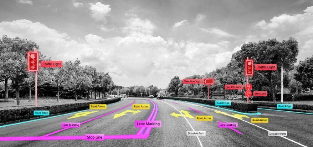
Figure 1: AV Map—Semantic Attribution (Source: Mobileye)
Examples of Mapping for Autonomous Cars
To get a better understanding of how autonomous vehicles take advantage of digital mapping, here are three popular products OEMs are turning to.
HERE HD Live Map
In 2021, the company HERE reported on its website that its HD Live Map would be used in the DRIVE PILOT from Mercedes-Benz. This marked the very first commercially available SAE Level 3 (L3) automated driving system that was designed for specific driving conditions in Germany. With the HD Live Map system, the autonomous vehicle can gather information on road geometry from road signs and can adjust vehicle speed when a lane is about to close. This mapping platform can also account for “unusual traffic,” which includes things like accidents and road work.
TomTom RoadDNA
Amsterdam-based location technology provider TomTom provides a similar mapping product called RoadDNA. This product solves the localization shortcomings of traditional Global Positioning Systems (GPSs)—by delivering an accurate 3D and longitudinal position of the road. In tandem with vehicle sensors, the location of the AV is laser-focused and supports anticipated maneuvers. Like the AV mapping platform from HERE, TomTom’s HD map serves as the eyeballs of the surrounding environment—capable of detecting road signs and traffic lights and seeing around corners. Nine out of the top ten carmakers worldwide have included TomTom’s HD Map in their Research & Development (R&D) projects.
NVIDIA DRIVE Map
While NVIDIA is most known for its involvement in the gaming space, it also serves as a mapping company. The NVIDIA DRIVE Map leverages four localization technologies: camera, Light Detection and Ranging (LiDAR), radar, and Global Navigation Satellite System (GNSS). In some environments, like highways and urban developments, the NVIDIA DRIVE Map can make attributions at an accuracy of better than 5 Centimeters (cm) for vehicles with L3 and L4 autonomy. In addition to ground truth, NVIDIA DRIVE Map is possible through Artificial Intelligence (AI)-based crowdsourcing of vast sums of behavioral data that come from millions of connected vehicles. NVIDIA continues to create HD maps of busy highways in North America, Europe, and Asia—encompassing over 500,000 km of coverage.
What to Expect from the Market
The market opportunity for AV mapping will be worth more than US$300 million by 2027. A few years later, at the end of the decade, that number will climb to US$867 million. As for adoption, ABI Research expects all robotaxis and vehicles with SAE L3 and L4 functions to incorporate the technology. As early as 2024, SAE L2 vehicles will begin implementing AV maps, too, as the Average Selling Prices (ASPs) decrease to the sub-US$4 mark (subscription model) and mainstream car models can be targeted.
By 2030, SAE L2 vehicles will account for 43% of the total number of AVs with intelligent mapping technology (1.15 million cars), while L2+ vehicles will account for 49% of the market. Be that as it may, SAE L2 vehicles will make up less than one-fifth of AV map revenue, while 69% of the revenue in the market will come from L2+ vehicles.
To learn more about AV mapping, such as use cases, how the maps are built, and which companies are at the forefront, download ABI Research’s Automotive Maps for Intelligent Speed Assistance, ADAS, And Autonomous Driving research report. This report is part of the company’s Smart Mobility & Automotive Research Service.
 Jennie Baker